

Another New Concept? Understanding DeSPIN and 8 Projects Worth Watching
TechFlow Selected TechFlow Selected
Another New Concept? Understanding DeSPIN and 8 Projects Worth Watching
The core of DeSPIN lies in combining geographical information with environmental context to support human decision-making.
Author: cookies
Translation: TechFlow
As Web3 technology continues to evolve, the Decentralized Spatial Intelligence Network (DeSPIN) is emerging as a field of growing interest. By analyzing and leveraging real-world visual data, DeSPIN not only provides innovative solutions for map building, urban planning, and robotics, but also pioneers a new "Contribute-to-Earn" economic model. This article will delve into the core concepts, key protocols, and future directions of DeSPIN.

What is DeSPIN?
Spatial intelligence is a technology that extracts insights by analyzing real-world visual data. At its core, it combines geographic information with environmental context to support human decision-making. The Decentralized Spatial Intelligence Network (DeSPIN) integrates this concept with blockchain and the decentralized principles of Web3, creating an open, shared ecosystem. Imagine earning rewards simply by sharing photos of roads taken during your daily commute or by recording environmental data in malls and streets. This model lowers the barrier to data collection while incentivizing ordinary users to contribute to the advancement of spatial intelligence.
Before exploring DeSPIN’s specific applications, it's essential to understand the foundational framework of spatial intelligence. It consists of four core components:
-
Data Collection: Gathering data via sensor networks (e.g., cameras, GPS) and IoT devices such as smartphones and laptops.
-
Data Processing and Analysis: Using machine learning techniques to process geospatial metadata, identify patterns, and build spatial query databases.
-
Knowledge Representation: Associating data with environmental context through semantic mapping to deliver visualized geographic information.
-
Decision Support Systems: Building spatial prediction models to provide application services such as route optimization and obstacle avoidance.
Key Protocols in the DeSPIN Ecosystem
Currently, several innovative protocols have emerged within the DeSPIN space, each targeting different use cases. Below are eight notable projects:
1. Hivemapper
Hivemapper is a decentralized mapping protocol utilizing a "Drive-to-Earn" model. Users report road issues in real time via a mobile app, while drivers collect data using dashcams installed on vehicles. AI algorithms process this data to generate maps, with accuracy verified through human feedback reinforcement learning (RLHF). Hivemapper offers a coverage map showing which areas have been mapped and allows API access to the data. Contributors are rewarded with $HONEY tokens, which can be used to purchase map data or other services.
2. NATIX Network
NATIX Network is a decentralized mapping economy protocol focused on collecting road data via mobile devices and dashcams, also employing a "Drive-to-Earn" model. Its core VX360 technology enables 360-degree panoramic data capture, useful for developing driver assistance features like autonomous driving optimization. To date, NATIX Network has expanded to 171 countries, with over 223,000 registered drivers and 131 million kilometers of mapped roads. Both data contributors and network nodes receive $NATIX token rewards, further fueling ecosystem growth.
Both Hivemapper and NATIX aim to improve map quality through crowdsourced road data. Potential applications of this data include:
-
Optimizing Urban Mobility: Real-time road data analysis can enhance traffic flow management, reduce congestion, and improve transportation efficiency.
-
Monitoring Road Conditions: Timely detection and reporting of road damage, obstacles, or hazards help maintain infrastructure safety and reliability.
-
Detecting Crime and Violence: Combining map data with AI algorithms can assist in identifying and locating abnormal behaviors, supporting public safety initiatives.
These applications not only enhance map functionality but also bring tangible value to urban management and societal security.
3. FrodoBots
FrodoBots is a gamified data collection protocol using robots. Users remotely control ground robots to gather geospatial data via various input methods—controllers, keyboards, or gaming steering wheels. Researchers can also deploy AI navigation models on the platform for testing. Users earn FrodoBot Points (FBPs) by completing driving tasks, with points scaled based on distance and difficulty—longer and more challenging missions yield higher rewards. FrodoBots has conducted pilot tests in multiple cities and hosted navigation competitions between AI and humans. Additionally, the platform features an Earth Rovers School—a guild-like system allowing new users to rent Earth Rovers and participate in data collection.
4. JoJoWorld
JoJoWorld focuses on 3D spatial data collection, where users contribute data to train 3D models. The platform provides high-quality 3D datasets used to create digital scenes applicable in virtual reality and urban planning. Users can also directly purchase these 3D assets for personalized digital model development.
The next four protocols also focus on collecting real-world spatial data but target more specialized applications, such as robot model training. By addressing niche data needs and long-tail use cases, they expand the possibilities within the DeSPIN ecosystem.
5. PrismaXAI
PrismaXAI collects first-person-view data from specific scenarios such as hand-object interactions, dynamic movements, and social gatherings. Its Proof-of-View technology ensures data authenticity, while a decentralized validation mechanism improves annotation accuracy. This protocol holds significant potential for capturing long-tail data, offering unique advantages for model training.
6. OpenMind AGI
OpenMind AGI focuses on understanding the real world through Vision-Language-Action Models (VLAMs). Its core system, OM1, is a multi-platform operating system capable of interacting with dynamic real-world environments, making it ideal for customized robotics development. The platform gathers data via smartphones and robots, then shares it with developers to advance and innovate robotic applications.
7. MeckaAI
MeckaAI is a decentralized protocol for training robotic AI models. Users upload video data to train behavioral models for robots. The platform offers a mobile app, where users complete tasks to earn OG Mecka Points, incentivizing ongoing data contribution. MeckaAI aims to advance robotics through crowd-sourced data, significantly lowering the barrier to acquiring training datasets.
8. Xmaquina DAO
Xmaquina DAO is a decentralized autonomous organization (DAO) supporting open-source robotics projects. Unlike protocols directly involved in model training, Xmaquina DAO focuses on funding research and innovation in robotics through resource allocation. Its internal innovation lab, Deus Lab, drives robotics R&D, while MachineDAO uses $DEUS token staking and voting to determine which projects receive funding. This model supports the open development of robotics technologies while ensuring transparent and fair distribution of resources.
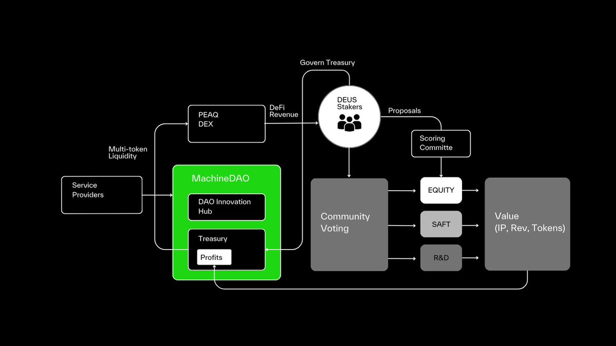
MachineDAO's organizational structure
Due to space constraints, several other promising protocols in similar domains are not covered here in detail, including Alaya_AI, Gata_xyz, and KrangHQ, all of which are worth watching.
The Future of DeSPIN: From Contribution to Value
Although still in its early stages, DeSPIN’s potential is undeniable. With advancements in physical AI and embodied AI, along with emerging concepts like the Human Data Fleet, DeSPIN could lead the next technological revolution.
A likely trend is the rise of the "Train-to-Earn" (T2E) model, where users contribute spatial data from daily life and receive rewards based on data quality. For instance, decentralized smart glasses could dramatically enhance the precision and diversity of data collection. Data captured by smart glasses not only reflects how humans perceive the world most authentically but also captures long-tail data such as environmental noise and facial characteristics, opening broader possibilities for spatial intelligence.
However, DeSPIN faces several challenges:
-
Data Validation: How can we ensure the authenticity and accuracy of crowdsourced data?
-
Ethical Concerns: How do we regulate data usage to prevent privacy breaches and misuse?
-
Adoption by End Users: Will traditional institutions adopt decentralized datasets?
Addressing these issues will shape the future trajectory of DeSPIN and requires continued research and innovation.
Join TechFlow official community to stay tuned
Telegram:https://t.me/TechFlowDaily
X (Twitter):https://x.com/TechFlowPost
X (Twitter) EN:https://x.com/BlockFlow_News