
Multicoin Capital: Why Geodnet is a Key Component in the Era of Physical AI?
TechFlow Selected TechFlow Selected
Multicoin Capital: Why Geodnet is a Key Component in the Era of Physical AI?
The AI-driven robotics revolution has become an irreversible trend, with the key being the timing of its full-scale outbreak.
Original: Shayon Sengupta, Investment Partner at Multicoin Capital
Translation: Yuliya, PANews

On February 25, prominent crypto investment firm Multicoin announced a strategic acquisition of $8 million worth of GEOD tokens from the Geodnet Foundation. Geodnet is a precise positioning network that provides critical location services for drones, autonomous vehicles, and potentially millions of future robots through the DePIN (Decentralized Physical Infrastructure Networks) economic model.
The Age of Physical AI Has Arrived
While we have not yet reached the futuristic scenario depicted in Blade Runner 2049 where humanoid robots coexist with humans, in 2025, specialized robots are quietly integrating into every aspect of modern life. Currently, language models are commoditizing intelligence, unleashing new creativity and transforming the nature of knowledge work. However, AI advancement is not limited to text, images, and video—it is extending into the physical world, with robotics becoming the next major frontier.
As AI model capabilities improve, their ability to understand and interact with the physical environment will significantly increase. This shift will give rise to new autonomous systems—from self-driving cars and humanoid robots to drones and industrial automation equipment—that will operate with unprecedented levels of intelligence and autonomy. To function effectively, all these robots must answer one fundamental question: Where am I?
Positioning: A $5 Billion Challenge
When tens of millions of autonomous and semi-autonomous devices are deployed, they all face the same challenge: spatial awareness. Drone deliveries, autonomous vehicles navigating dense urban environments, and agricultural machines performing precision seeding all require sub-centimeter positioning accuracy to operate safely and efficiently.
To achieve such high precision, these systems rely on sensor fusion, combining multiple positioning methods.
-
Lidar provides high-resolution depth mapping but performs poorly in fog or rain (and suffers from being heavy, power-hungry, and expensive).
-
Radar offers robust distance measurement but lacks fine precision.
-
Visual-based SLAM enables real-time mapping but experiences significant performance degradation in low-visibility conditions.
Among existing positioning solutions, GNSS (Global Navigation Satellite System) combined with RTK (Real-Time Kinematic) base station corrections is widely recognized as one of the most reliable approaches.
Standard GNSS positioning inherently has accuracy errors of 5–10 meters due to atmospheric interference and multipath effects. RTK solves this by using fixed base stations to compare satellite signals against known positions and transmitting real-time correction data, achieving centimeter-level accuracy—critical for physical AI applications. Today, leading robotics and automation companies integrate RTK into their systems:
-
DJI for high-precision drones;
-
John Deere for autonomous tractors;
-
Tesla for autonomous vehicles;
-
Boston Dynamics for industrial inspection robots.
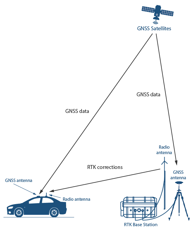
Image source: GNSS Store
However, RTK currently faces cost challenges. Building and maintaining RTK base stations requires substantial capital investment across hardware, site acquisition, and ongoing maintenance. Traditional providers like Trimble, Hexagon, and Topcon build their own stations and charge thousands of dollars per tracked device, limiting accessibility and deployment speed. Coverage tends to be concentrated in profitable areas, leaving many regions without access to high-precision positioning services.
Restructuring the Cost Model via DePIN
The token-incentivized contributor ownership model of DePIN fundamentally restructures the cost architecture of global, hardware-intensive networks. As the world’s largest precise positioning network, Geodnet leverages this principle to incentivize independent operators to install RTK base stations and provide correction data in exchange for token rewards.
By shifting the cost burden from a single operator to a distributed network, Geodnet can deploy production-grade RTK stations at a fraction of the cost of traditional providers, primarily by eliminating two major network-building expenses: land and labor. This allows Geodnet to expand coverage faster, ensure redundancy, and deliver more reliable GNSS correction services than existing providers.
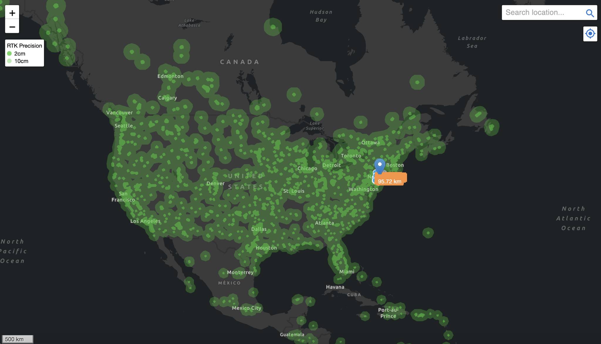
This model creates an organically expanding global distributed network that significantly reduces end-user costs while maintaining service quality. Since last year, Geodnet has rapidly expanded—from 1,400 base stations in November 2022 to 7,800 by June 2024, and over 13,000 by January 2025, covering 4,377 cities across 142 countries.
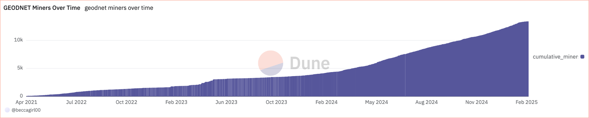
Geodnet has now achieved "threshold scale," with service capacity covering over 60% of the GNSS correction market. Notably, this supply has been achieved with extremely high capital efficiency—only 11% of tokens have been distributed to contributors over the past three years.
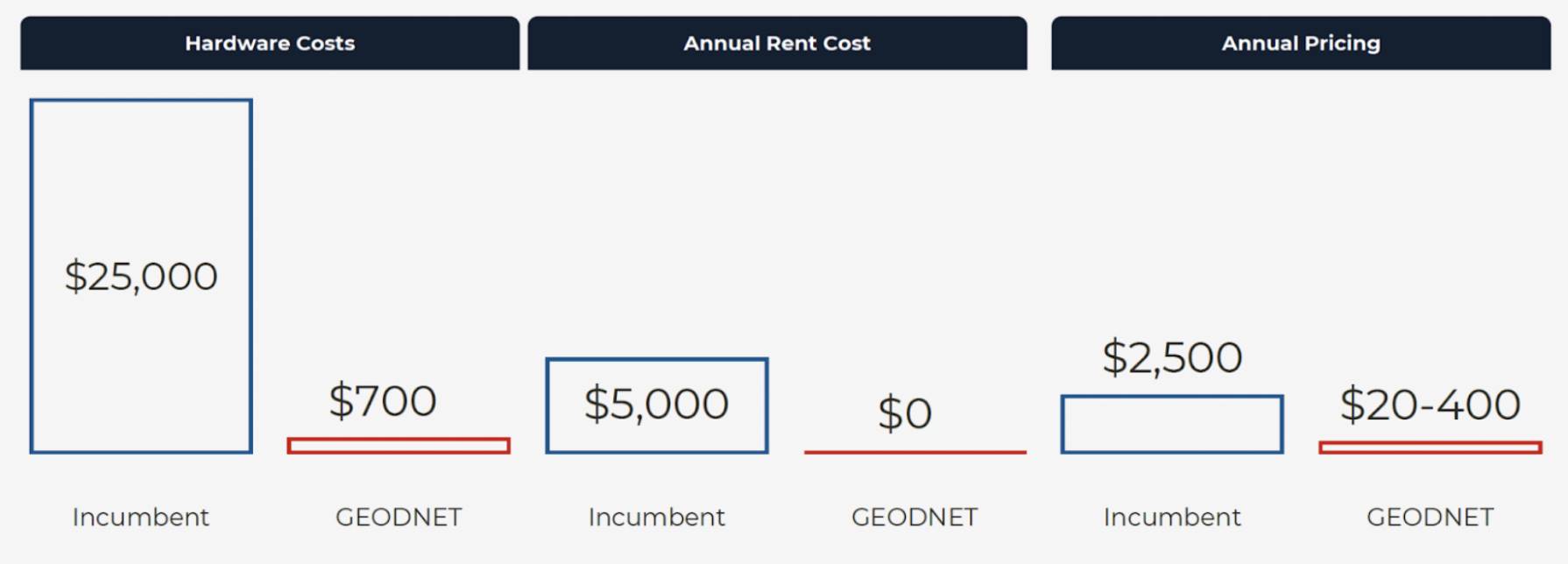
Geodnet stands as a prime example of the DePIN model in practice. Geodnet base stations are not only an order of magnitude cheaper to purchase and deploy ($700 consumer-grade miner vs. $12,000 enterprise RTK station), but annual pricing is also dramatically reduced thanks to denser consumer-grade network deployment. Geodnet is undoubtedly today’s most scalable and cost-competitive global positioning solution.
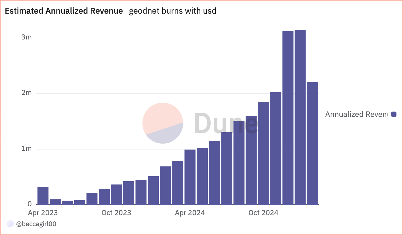
Currently, Geodnet generates approximately $3 million in annualized on-chain revenue by serving drone industry leaders such as Propeller, DroneDeploy, Quectel, and government agencies like the USDA (U.S. Department of Agriculture), demonstrating the fastest demand-side growth in the DePIN space.
In early conversations with Geodnet founder Mike Horton, when asked how he secured some of the most influential customers in autonomous driving, drones, and agricultural robotics globally, his answer was always the same: the core structural cost advantage enabled by the DePIN model.
The Tipping Point Has Arrived
In the next decade, robotics will enter a period of explosive growth. From industrial manufacturing to daily life, tens of millions of robots are expected to be deployed across various sectors. Drones will inspect power lines and pipelines from the air, autonomous vehicles will reshape freight and mobility services, smart warehouse robots will replace human labor at scale, and household humanoid robots will gradually enter homes to assist with everyday tasks.
Precise positioning capability is the cornerstone of this robotic revolution. Without reliable positioning data, no autonomous robot can perform its intended functions effectively. For example, autonomous vehicles must rely on RTK-enhanced GNSS systems to navigate safely in urban canyons where GPS signals are weak; delivery drones similarly require centimeter-level accuracy to land precisely at designated charging stations. Therefore, RTK positioning is no longer merely a supplement to sensors like lidar and radar—it has become critical infrastructure for robotic operations.
Currently, numerous robotics companies pay high fees annually for traditional GNSS correction services, yet still face issues such as limited coverage and unstable accuracy. In contrast, Geodnet, through its innovative DePIN model, not only significantly reduces service costs but also delivers superior positioning quality. This breakthrough solution is attracting an increasing number of enterprise clients, providing reliable positioning assurance for current and future autonomous robots.
The AI-driven robotic revolution is now an irreversible trend—the key question is when it will fully erupt. The robotics industry is accelerating, and Geodnet’s precise positioning network will ensure these robots can operate safely and efficiently. In the coming age of robotics, Geodnet’s positioning services will play an irreplaceable role, delivering accurate and reliable location information support to robots worldwide.
Join TechFlow official community to stay tuned
Telegram:https://t.me/TechFlowDaily
X (Twitter):https://x.com/TechFlowPost
X (Twitter) EN:https://x.com/BlockFlow_News